![]()
![]()
PDC Highlights
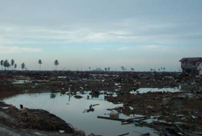
Devastation in Banda Aceh, Indonesia. This photograph was taken during PDC’s deployment to the region immediately following the earthquake and tsunami disaster.
The Great Sumatra-Andaman Islands Earthquake and Indian Ocean Tsunami, which struck on December 26th 2004, has claimed over 200,000 lives across countries including Sri Lanka, India, Indonesia, Thailand, Burma, Malaysia, the Maldives, and Somalia.
In the immediate aftermath of
the disaster, the first message received by PDC from an emergency
manager in the region read, “We badly need maps.” In
response, a ![]() Map Viewer and
Map Viewer and
![]() Geographic Information Systems
service has been launched to serve the humanitarian relief
community.
Geographic Information Systems
service has been launched to serve the humanitarian relief
community. ![]() PDC’s
public web page also provides information products, damage
assessment maps, and news links on this developing
situation.
PDC’s
public web page also provides information products, damage
assessment maps, and news links on this developing
situation.
What's New
Tsunami Response Activities
![]() Southeast Asia and Tsunami Response Map Viewer
Southeast Asia and Tsunami Response Map Viewer
Supporting the general public and GIS users, an easy-to-use
interactive map of the impacted area is now available that
includes downloadable high-resolution imagery, shaded relief images,
population density, detailed coastlines, and damage polygons.
![]() Indian Ocean Tsunami Response
Indian Ocean Tsunami Response
Geospatial Information Service
To support the GIS data needs of emergency managers, a new
spatial information map service has launched that also contains downloadable data from the Map Viewer.
This service is part of the
Asia Pacific Natural Hazards Information Network (![]() http://apnhin.pdc.org/).
http://apnhin.pdc.org/).
Field Deployments
Six
members of the PDC team have provided assistance in the
field in the
disaster’s aftermath. This includes geospatial support for the
Government of Thailand, United States Pacific Command, as well as
the World Health Organization in Banda Aceh,
Indonesia.
International Highlights
ASEAN Collaboration
To facilitate the exchange of
disaster-related data among the ten Association of South East Asian
Nations (ASEAN) countries, the Pacific Disaster Center and the
ASEAN Committee on Disaster Management (ACDM) are collaborating on a
Disaster Information Sharing and Communication Network. The
project was officially endorsed at a December 7-8, 2004 ASEAN
ministers meeting in Phnom Penh, Cambodia.
Pacific Islands Disaster Management Training
In partnership with East-West
Center, PDC co-sponsored and conducted a two-week seminar that
brought together national disaster managers from 17 Pacific Island
nations and states in Honolulu from October 18-29, 2004. The seminar
provided training on leadership skills, policy issues, new risk
reduction methodologies and applications, and also included a
tsunami risk reduction tabletop exercise.
Hawaii Support
![]() Severe flooding impacted the Island of Oahu’s Manoa region in November 2004. To assist Hawaii State Civil Defense during this emergency, PDC provided imagery products of impacted areas that were displayed in the Emergency Operations Center and at the Disaster Assistance and Recovery site in Manoa. The products have also been used in high-level briefings to state legislators and other officials.
Severe flooding impacted the Island of Oahu’s Manoa region in November 2004. To assist Hawaii State Civil Defense during this emergency, PDC provided imagery products of impacted areas that were displayed in the Emergency Operations Center and at the Disaster Assistance and Recovery site in Manoa. The products have also been used in high-level briefings to state legislators and other officials.
Hawaii Community Outreach
![]() Maui County Volunteer Organizations Active in Disaster (VOAD) held meetings in October and November at PDC, which included a PDC-designed fire tabletop exercise. Maui VOAD is an umbrella organization comprising over 60 volunteer agencies in Maui County.
Maui County Volunteer Organizations Active in Disaster (VOAD) held meetings in October and November at PDC, which included a PDC-designed fire tabletop exercise. Maui VOAD is an umbrella organization comprising over 60 volunteer agencies in Maui County.
Of Note . . .
![]() The landmark World Conference on Disaster Reduction convened January 18-22, 2005 in Kobe, Japan. As an official participant, Pacific Disaster Center showcased geospatial information products also co-sponsored a thematic session and two-day symposium on risk and vulnerability for Megacities. More details in the next issue…
The landmark World Conference on Disaster Reduction convened January 18-22, 2005 in Kobe, Japan. As an official participant, Pacific Disaster Center showcased geospatial information products also co-sponsored a thematic session and two-day symposium on risk and vulnerability for Megacities. More details in the next issue…
The ![]() East-West Center’s 2005 Asia Pacific Outlook features Impact Of Natural Disasters Takes Center Stage, by PDC Executive Director Dr. Allen Clark.
East-West Center’s 2005 Asia Pacific Outlook features Impact Of Natural Disasters Takes Center Stage, by PDC Executive Director Dr. Allen Clark.
PDC is pursuing a program with the Earthquakes and Megacities Initiative (EMI) to reduce earthquake risk in complex urban environments, and will complete activities in Kathmandu, Nepal, and Manila, Philippines in 2005.